Amberreach Region - AI-generated fantasy Region

Amberreach Region

Amberreach Region
Region AtlasCity-State RegionRegional (50-150 miles)

Amberreach Region

Where glass sings under the sun and water buys power.

PopulationConcentrated around ports, wells, and irrigated…
ClimateMediterranean warmth with hot dry summers, mild…
TerrainPredominantly desert with rocky outcrops,…
StabilityFragile equilibrium maintained by merchant wealth…
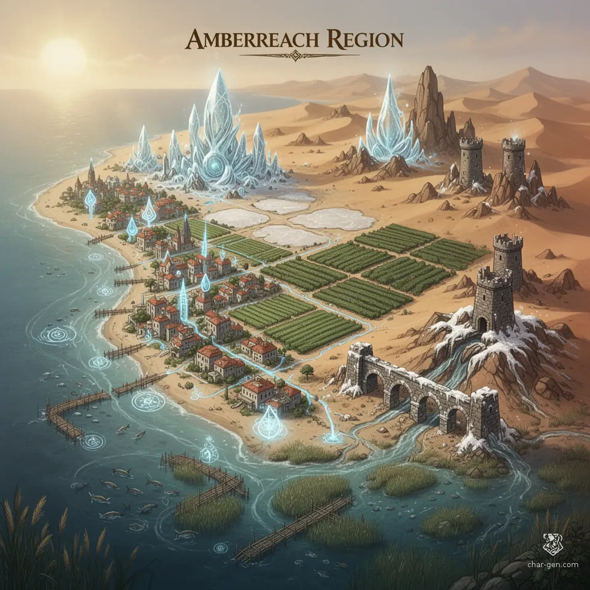
Amberreach is a regional network of city-states clustered along a sunlit coast and the irrigated valleys behind it, spanning roughly a day's travel across its breadth. Mediterranean warmth fosters lush terraces amid a harsh desert, where common magic aids water conservation and navigation. Merchant councils, caravan wardens, and arcane workshops vie for influence while the sea and the salt flats connect and challenge settlements across the region.

Field Observations

Sea routes are faster but subject to seasonal storms.,Caravan travel requires knowledge of wells and is slowed by soft sands.

Cultures

Maritime merchants who value contracts and speed of delivery.

Nomadic desert clans who prize water rights and oral law.

Terraced agrarians who practice careful irrigation and song-based rites.

Industries
Maritime trade and ship provisioning.
Salt refining and glassmaking from desert sands.
Terraced agriculture producing dates, olives, and wine.
Trade Goods
Refined salt and polished glassware.
Dried fruits, olive oil, and preserved fish.
Spices, textiles, and arcane reagents.
Imports
Timber and fine lumber arrive by sea.
Metal ore and finished tools are imported from inland regions.
Trade Hubs
Main port city serves as the largest market and shipyard.
Major caravan crossroads supports inland exchange.

Geography

ClimateMediterranean warmth with hot dry summers, mild wet winters, and occasional flash floods.
TerrainPredominantly desert with rocky outcrops, terraced valleys, and a scattering of saline flats.
Biomes
Stony coastal desert with sparse scrub and wind-polished rock formations.
Irrigated terraces and orchards in narrow valley enclaves.
Salt flats and seasonal playas that reflect fierce sunlight.
Waterways
A slow, silted river threads the irrigated valleys and feeds orchards.
A chain of oases provides lifelines for inland caravans.
A coastal lagoon and tidal marshes shelter small harbors.
Borders
Basalt mesa range marks the northern highland edge of the region.
Open desert stretches toward the inland dunes to the south.
A shallow coastal shelf shapes the maritime boundary.

Demographics

Coastal merchants dominate trade and ship ownership.
Desert pastoralists herd goats and camels across the dunes.
Terraced farmers manage irrigated orchards and vineyards.
Minor Groups
Itinerant craftsfolk and migrant laborers.
Small communities of foreign sailors and traders.
Languages
Common tongue is used for trade and everyday talk.
Mariner Cant is used by sailors and dockworkers.
Desert Argot is used by caravans and nomads.

Economy

Status

Moderate with wealthy merchant families concentrated in port districts.

Visual sheet

Turn Amberreach Region into a sheet

A high-res, share-ready sheet you can post or print.

Gallery

Amberreach Region Image

Amberreach Region Image

Settlements

Harborfall

CityLarge city

Major port and regional market.

Sunwell Oasis

Oasis townTown

Key water source and caravan stop.

Saltbridge

Market townTown

Processing and export hub for salt and glass.

Terraced Vale

Farming clusterVillage

Agricultural heartland supplying fruit and wine.