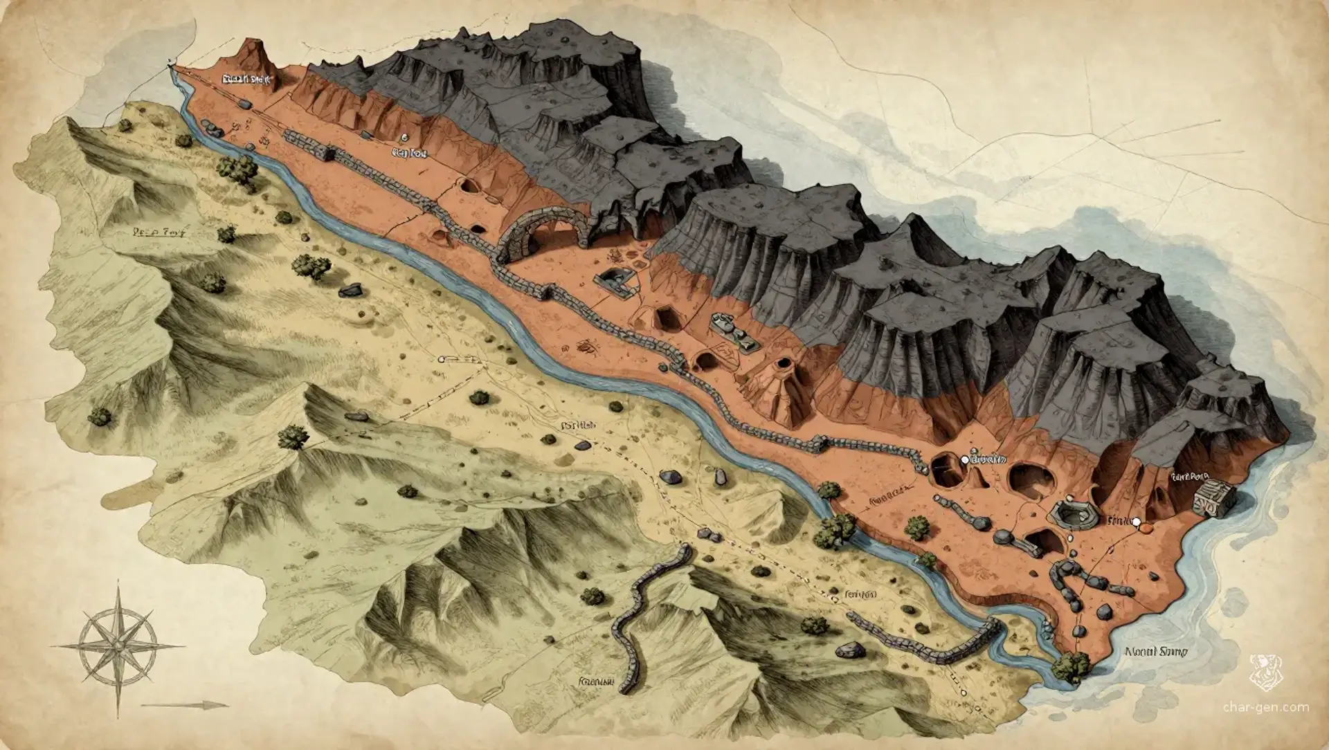
Basalt Steps is a broad upland homeland where Veyr communities occupy both sunlit market roads and deep networks of worked galleries. Stone, clay, and metal shape daily life, but no two Veyr bodies need share the same composition or craft history. Settlements cluster around water, safe entrances, and productive seams, with caravans linking remote workshops to neighboring regions. The land rewards patient travel and skilled hands, yet floods, unstable tunnels, and contested claims keep every route consequential.
Cultures
Veyr craft traditions honor the distinct materials and carefully fitted joints of each self-aware construct.
Kilnside communities gather around shared firing yards and maintain close ties with surface traders.
Ridge-road customs blend Veyr practices with those of neighboring caravan peoples.
Places
5 settlements
Large · Ford townClay FordRiver crossing and trade marketA busy crossing combines a market, ferry landing, and workshops for repairing caravan gear.
Medium · Kiln villageThird KilnCeramic production centerIts broad firing yards produce durable wares and draw seasonal workers from nearby galleries.
Large · Gallery townBasalt ShelfQuarry and stoneworking centerHomes and workshops occupy ledges above a productive quarry, with tunnels descending beneath the ridge.
Small · Road stationReedwashWater stop and caravan stationA modest settlement grows around a seasonal creek and serves caravans crossing the eastern grass benches.
Medium · Gallery settlementNorth SumpUnderground route and waterworks hubIts maintained galleries provide a sheltered route and house crews who inspect underground waterways.
How they spread
PatternCommunities cluster near water, workable stone, and safe gallery entrances, while small camps follow active seams and seasonal routes. The largest markets sit where ridge roads meet river crossings.
Common kinds
Gallery towns, Quarry camps, Ford markets, Kiln villages
Trade routes
The Ridge Road follows the northern escarpment between upland markets.
The Ford Track links river crossings to the western salt flats.
The Kiln Road carries ceramics and metalwork between gallery towns.
The Deep Way connects maintained underground passages between established settlements.
Dangers and hooks
4 threats
Most dangerous · HighThe Sudden WashFlash floodingSeasonal, especially after storms beyond the northern ridges.
The Slag BurrowersHighPredatory subterranean creatures
Uncommon, but reported near old firing yards and warm vents.
Hollow CeilingModerateStructural hazard
Persistent in abandoned mines and newly cut galleries.
ClaimbreakersModerateArmed labor conflict
Active around disputed seams and isolated quarry camps.
Hazards of the land
Flash floods sweep through dry ravines after distant storms.
Unmarked galleries contain unstable ceilings and sealed shafts.
Fine quarry dust can obscure roads and irritate exposed travelers.
Old slag pits conceal hot ground and brittle crusts.
Plot hooks
1
The Unmarked JointsInvestigationA newly exposed gallery contains joint fittings bearing marks that match no known local workshop.Starts: A quarry crew asks for discreet help after sealing off a chamber beneath the east ridge.Reward: A rare set of fittings, a trusted guide, or a share in the recovered materials.
2
Water Under the FordDiplomacy and explorationThe Clay Ford crossing has become unusable, and nearby communities accuse one another of diverting the stream.Starts: Delegates at a fordside market hire escorts to trace the water upstream.Reward: A negotiated toll waiver and favor from the river settlements.
3
The Missing LoadRescueA caravan carrying essential furnace fuel vanished along a route thought safe in winter.Starts: The caravan's last known stop is a road station beneath a ridge shelf.Reward: Trade goods, a map of hidden routes, or a standing contract.
4
Lines Through StoneDiscoveryA set of old survey marks suggests a rich seam crosses several active quarry claims.Starts: A cracked stone marker is found in the abandoned kiln belt.Reward: A legal claim, mining rights, or payment from the settlement councils.
The land
Climate and ground
ClimateDry continental climate with hot summers, cold nights, and brief, forceful rains.
TerrainA broad upland basin cut by ridges, ravines, quarries, and extensive inhabited galleries beneath the surface.
Biomes
Dry upland scrub, Sheltered river groves, Cave and gallery ecosystems, High grass benches
Waters and borders
Waterways
The Red Cut stream
Clay Ford river
North Sump underground channel
Reedwash seasonal creek
Borders
A broken escarpment to the north
Open grazing uplands to the east
A chain of low ridges to the south
Salt flats to the west
On the road
Surface roads become difficult after sudden storms, when dry channels flood without warning.
Marked gallery routes are reliable, but unmaintained tunnels can dead-end or collapse.
Caravans favor the ridge roads in winter and the shaded waterways in summer.
Landmarks
A long wall of dark stone bears old survey marks.
Warm vents rise through cracks above the deeper galleries.
The Red Cut stream vanishes beneath a natural stone arch.
A scatter of abandoned kilns marks an early settlement belt.
Landforms
Layered basalt ridges
Clay shelves and ravines
A broad central upland basin
Limestone galleries and sinkholes
Resources
Basalt and limestone
Fired clay and ceramic minerals
Copper and iron-bearing stone
Spring water and medicinal cave moss
Power
Rule
GovernmentA network of settlement councils sends delegates to a rotating regional assembly; craft halls and Veyr civic circles hold recognized advisory roles.
SeatThe regional assembly meets in a shared hall whose location rotates among the larger settlements.
StabilityGenerally steady, though disputes over water, excavation, and surface access flare during lean seasons.
Laws
Quarry claims must be marked and renewed on the public rolls.
No one may alter another Veyr's joints or body without consent.
Water rights and ford tolls are reviewed at open assemblies.
Factions
Quarry Roll NineCraft and labor compact
Influence: Strong in the western cuts and among stoneworkers.Keep quarry rights and access roads under local control.
Joint HallCivic assembly
Influence: Widespread among Veyr settlements and respected by many surface neighbors.Preserve the independence and legal standing of every self-aware Veyr.
The Long GradeCaravan league
Influence: Practical influence at markets, fords, and road stations.Secure reliable passage for caravans and standardize tolls at crossings.
Faiths
The Deep Measure
Influence: Strong among quarry crews and gallery communities.Honoring the deep earth as a patient source of material, shelter, and memory.
The Fitted Way
Influence: Widespread among Veyr, with local variations in practice.Marking personal making and selfhood through rites of joining and repair.
Fordside Vows
Influence: Most visible at fords, springs, and caravan stops.Seeking balance between flowing water, settled homes, and the needs of travelers.
People and trade
Who lives here
How manyModerate, concentrated near dependable water, accessible galleries, and busy trade roads.
Main peoples
Veyr constructs assembled from stone, fired clay, metal, and fitted joints
Surface-dwelling traders and craft workers
Caravan families from the surrounding uplands
Other peoples
Seasonal quarry crews
Wayfarers from the eastern plateau
Languages
Veyric, spoken in many regional accents
Trade Speech, common at markets and border roads
Cairn Cant, used by quarry crews and tunnel guides
Trade
WealthUneven but broadly prosperous along trade roads, with remote communities relying on local materials.
Work
Quarrying and stone shaping
Ceramic firing and metalworking
Caravan trade and repair crafts
Exports
Worked stone and fired-clay wares
Brass fittings and joint pins
Surveyed maps and tunnel guides
Imports
Grain and preserved fruit, Fine tools and furnace fuel
Markets
Clay Ford, Third Kiln, Brass Bend
History and secrets
The region grew where stone, clay, and metal lay close enough for Veyr makers to build enduring communities. Generations of quarrying created the galleries that now shelter homes, workshops, and meeting halls. Surface trade brought wealth and outside influence, while disputes over excavation, water, and access repeatedly reshaped local agreements. Veyr identity remains rooted in self-determination and the varied materials from which each person is made.
Key events
First Settlements
The Open CutsEarly Veyr communities established galleries beside workable stone and reliable water.
Old Measures
The Joined SurveyA series of tunnel failures led communities to establish shared inspection marks and rescue duties.
Trade Expansion
The Ford Road CompactCaravan traffic increased after safer ford crossings connected the uplands to western markets.
Secret 1 · GM only
A sealed network of deep passages links several communities beneath the known quarry levels.Found by: Compare the oldest gallery marks with the orientation of warm vents beneath the central basin.If found: The hidden network could provide safe passage across the region, but opening it may destabilize inhabited galleries.
Secret 2 · GM only
An old survey was deliberately shifted to conceal a valuable seam beneath multiple settlements.Found by: Look for mismatched survey stones near the western salt flats and check their dates against tax records.If found: Revealing the alteration could overturn established claims and provoke a regional dispute.
Secret 3 · GM only
A buried assembly chamber holds unfinished constructs that may be self-aware.Found by: Listen for a repeating pulse in a disused firing yard after its kilns have cooled.If found: The discovery could transform Veyr understanding of selfhood and creation, or become a dangerous political weapon.
Connections
Media
0 images
No images yet.
Visual sheet
Turn Basalt Steps into a sheet
A high-res, share-ready sheet you can post or print.