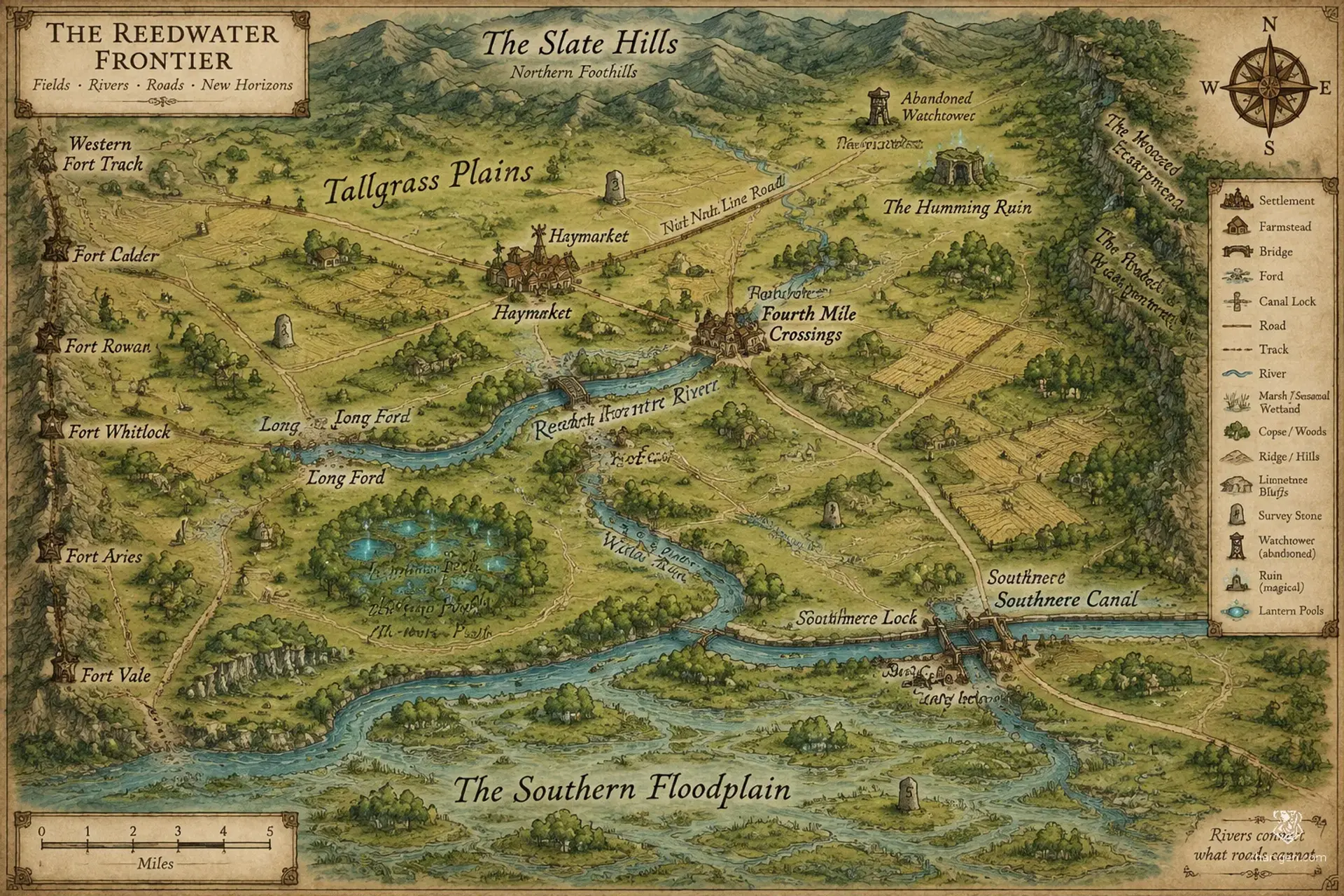
Old survey lines cross a living frontier of grass, water, and unsettled claims.
NRNinth Survey Reach
Overview
The Ninth Survey Reach is a broad frontier of open grassland, working farms, and half-kept roads, spanning roughly a hundred miles from the Slate Hills to the southern floodplain. Its old survey grid promises orderly settlement, yet rivers shift, boundary stones vanish, and wild magic sometimes bends familiar paths. Travelers find busy market crossings separated by lonely homesteads, while ambitious settlers, herders, and road wardens compete to decide who may use the land and its hidden resources.
Cultures
The Haybelt tradition values shared labor, seasonal fairs, and practical hospitality.
The Survey Line communities keep old boundary customs and mark public works with numbered stones.
The Fordfolk blend river trade practices with migratory herding traditions.
Places
4 settlements
Large · Market townHaymarketRegional market and meeting placeIts weekly grain exchange draws farm families, caravan crews, and traveling spellcasters.
Medium · Roadside townFourth Mile CrossingsTransport junction and caravan stopSeveral roads converge at shallow fords beside a busy repair yard.
Small · Ford villageNorth FordRiver crossing and border watchA timber bridge and ferry share the crossing, while local wardens watch the northern approach.
Small · Canal settlementSouthmere LockCanal port and supply depotCanal workers maintain its lock gates and trade goods from barges with nearby farms.
How they spread
PatternSettlements cluster at reliable water, defensible crossings, and intersections of old survey roads. Isolated farmsteads and seasonal herder camps fill the spaces between them.
The Ninth Line Road links northern pasture to southern grain markets.
The Reedwater route carries bulk goods between river landings.
The Western Fort Track connects watch posts and border crossings.
Dangers and hooks
3 threats
Most dangerous · HighLantern Pool WraithsUndead spiritsThey gather near floodwater and abandoned survey stones, especially after storms.
The Unmoored CurrentHighMagical hazard
It appears along the canal and river bends where old magic disturbs the water.
Prairie BreakersModerateHumanoid raiders
Small bands raid isolated wagons and vanish into tall grass.
Hazards of the land
Flash floods across low crossings
Prairie fires driven by strong winds
Unstable earth where old wells and buried culverts have collapsed
Plot hooks
1
The Wandering MarkerInvestigationA survey marker has appeared overnight several miles from its recorded position, and nearby farms are claiming one another's fields.Starts: The boundary dispute is brought before a seasonal moot at Haymarket.Reward: A deed to a modest homestead and the favor of the local road wardens.
2
Grain on the Empty RoadRecoveryA shipment of seed grain vanished on the open road, and its wagon tracks end at a dry well that glows after sunset.Starts: The caravan's surviving driver waits at Fourth Mile Crossings.Reward: A share of recovered cargo and a charm that reveals buried water.
3
The Reversed FlameSupernatural threatA prairie fire moves against the wind and circles a hamlet rather than consuming it.Starts: Residents of North Ford ask for help before the next nightfall.Reward: A fire-resistant token and a public service bounty.
4
Water Against the GradeExplorationThe Southmere Canal has begun flowing uphill, drawing fish and strange lights toward an abandoned watchtower.Starts: Canal workers offer passage from Haymarket to the affected lock.Reward: A cache of old survey maps and a modest payment from the canal guild.
The land
Climate and ground
ClimateTemperate, with windy summers, wet springs, and winters that bring occasional hard freezes.
TerrainWide open plains broken by gentle ridges, shallow valleys, river bluffs, and scattered copses.
The Reedwater River, The Long Ford, The Willow Run, The Southmere Canal
Borders
A low wooded escarpment to the east
The Slate Hills foothills to the north
A chain of old forts to the west
The broad southern floodplain
On the road
Rain can turn unpaved tracks into axle-deep mud within hours.
Distances are deceptive across the open grass, and few landmarks rise above the horizon.
Magic-lit survey posts make reliable night markers but sometimes attract curious spirits.
Landmarks
Numbered stone posts from the first land survey
A ring of abandoned watchtowers along the western road
A grass-covered ruin whose stones hum during thunderstorms
The Lantern Pools, where will-o'-wisps gather after rain
Landforms
Long low ridges
Shallow river valleys
Broad floodplain
Scattered limestone bluffs
Resources
Fertile black soil
Limestone
Iron-bearing bog ore
Abundant freshwater springs
Power
Rule
GovernmentA loose frontier compact of market councils, farmstead elders, and elected road wardens.
SeatA rotating council meets at whichever market settlement hosts the seasonal moot.
StabilityFunctional but fragile, with rival land claims and distant authority leaving many decisions to local custom.
Laws
Roads and marked wells must remain open to travelers.
Disputes over grazing are heard at seasonal moot gatherings.
Unlicensed spellwork that endangers crops or water is punishable by restitution.
Anyone may claim unoccupied land after recording its boundaries with local witnesses.
Factions
Hay Factors' CompactMerchants' league
Influence: Strong in market towns and among large farmsteads.Secure fair prices and keep grain moving through the region.
Ninth Line SurveyorsCivic order
Influence: Moderate, strongest near old survey markers.Restore boundary stones and claim authority over disputed roads.
Open Range MootLandholders' assembly
Influence: Broad among herders and smallholders.Protect grazing access and resist enclosure of common pasture.
Faiths
Waystone Veneration
Influence: Common among teamsters, innkeepers, and road wardens.Roadside offerings, safe passage, and the duties owed between host and traveler.
Granary Observance
Influence: Strong in farming communities and seasonal fairs.Harvest cycles, communal stores, and the spirits believed to dwell in fertile soil.
Ninth Measure
Influence: Respected at councils, though followed unevenly beyond settled roads.Oaths, measured boundaries, and the protection of wells and common land.
People and trade
Who lives here
How manyLow overall, with denser clusters around river crossings, market roads, and defensible wells.
Main peoples
Human farming and herding communities
Halfling caravan families
Dwarven roadwright and metalworking enclaves
Other peoples
Gnome hedge-mages, Orcish horse breeders
Languages
Common, Trade Cant, Dwarvish, Halfling
Trade
WealthModest and uneven, with prosperous market families beside isolated subsistence farms.
Work
Grain and hay production
Horse and cattle raising
Wagon repair and road transport
Exports
Wheat and barley
Horses and cattle
Woven blankets and leather goods
Imports
Iron tools and worked metal
Salt and lamp oil
Fine cloth and medicinal herbs
Markets
Haymarket, Fourth Mile Crossings, North Ford
History and secrets
The region grew around old military roads and a survey grid intended to organize distant crown lands. Farmers, herders, and traders filled the open country, adapting the grid to seasonal water and grazing. The frontier compact formed after distant officials stopped settling local disputes. Old claims remain written on weathered markers, while common magic and uncertain borders make the land promising, contested, and difficult to govern.
Key events
Old Survey Era
The Ninth LineSurvey crews marked a broad strip of pasture and road reserves, creating boundaries still used in local disputes.
Settlement Era
The Granary CompactA succession of poor harvests drove settlers to pool seed stores and establish shared granaries.
Recent Years
The South Bank FloodA flood shifted the Reedwater channel and stranded several hamlets on the wrong side of newly claimed land.
Secret 1 · GM only
The original survey grid was laid over an older network of arcane channels, and several boundary stones are also control points.Found by: A survey post bears a second set of markings visible only when its shadow crosses the ground at noon.If found: The marks outline a buried magical conduit that could redirect water across the region.
Secret 2 · GM only
A prominent group of landholders has been using a copied survey record to claim common pasture as private property.Found by: Compare old tax rolls with the names scratched beneath the western watchtowers.If found: A forged land claim could trigger a wider conflict between settlers and herders.
Secret 3 · GM only
The lights at the pools are remnants of a failed magical warning system that still responds to danger on the old road.Found by: Listen for bells beneath the Lantern Pools during a windless night.If found: The spirits may be calmed, bargained with, or driven into settled areas.
Media
0 images
No images yet.
Visual sheet
Turn Ninth Survey Reach into a sheet
A high-res, share-ready sheet you can post or print.