Where the wind rises, the trail is written in stone and color.
THThe Cut Heights
Overview
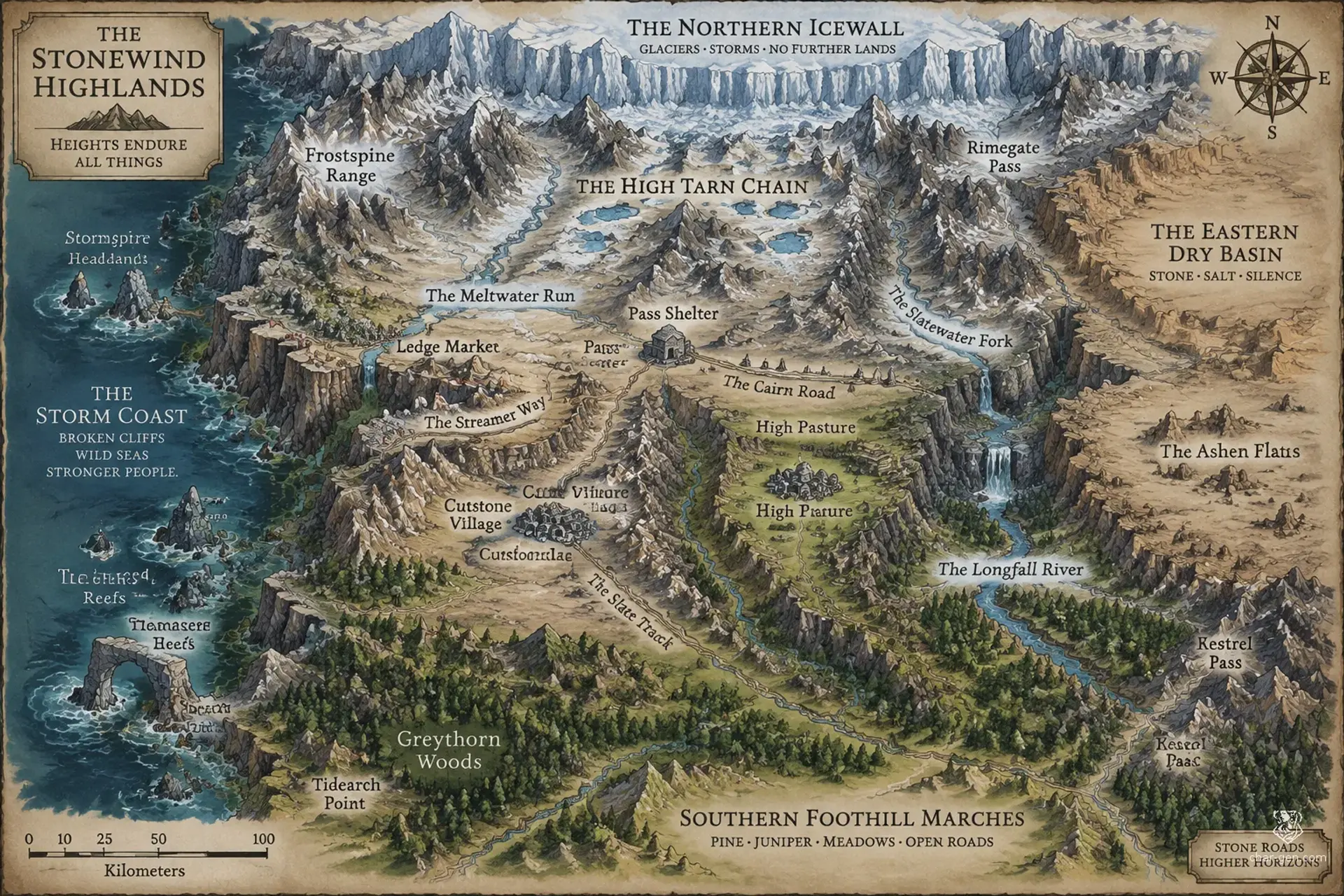
The Cut Heights are a broad highland homeland of the Kestrelkin, where steep ranges overlook open plateaus and narrow valleys. Settlements cling to ledges or gather behind stone windbreaks, their roofs shaped to vent fierce gusts. Powerful updrafts rise where cliffs meet open country, making the region a natural corridor for gliders and daring couriers. Cairns, carved posts, and bright streamers guide travelers, though weather can turn a familiar route dangerous in minutes.
Cultures
Kestrelkin cliff communities preserve ledge-building, wind-reading, and shared terrace traditions.
Lowland Kestrelkin blend highland customs with market-town crafts.
Roadside cultures value cairn-keeping and hospitality to travelers.
Places
4 settlements
Large · Market townLedge MarketRegional exchange centerIts broad gathering terraces host seasonal fairs and disputes over trail rights.
Medium · Cliffside villageCutstone VillageQuarrying and masonryStone windbreaks shield compact homes beside several active quarries.
Small · Fortified waystopPass ShelterPassway service stationIts watch posts offer guides, repairs, and refuge when storms close the road.
Small · Plateau hamletHigh PastureHerding and wool tradeFamilies move between sturdy stone homes and seasonal grazing camps.
How they spread
PatternSettlements cluster around sheltered ledges, reliable springs, and the crossings between plateaus. Isolated homes and seasonal camps occupy grazing slopes and high trails.
The Cairn Road links plateau markets to the southern foothills.
The Slate Track carries quarry goods through the western passes.
The Streamer Way follows glider posts between cliff settlements.
Dangers and hooks
3 threats
Most dangerous · HighThe Falling FaceEnvironmental hazardRockfalls recur along the busiest cliff roads, especially after heavy rain or thaw.
Whiteout BroodsHighMonstrous wildlife
Predatory highland beasts descend toward settlements during lean winters.
Pass-TakersModerateBanditry
Small raiding bands target isolated caravans and disappear into ravines.
Hazards of the land
Sudden crosswinds can throw travelers from exposed paths.
Avalanches and rockfalls close mountain passes without warning.
Thin air and freezing nights endanger the unprepared.
Updrafts can carry embers from terrace hearths into dry grass.
Plot hooks
1
The Misleading StreamersInvestigationA chain of trusted trail markers has been shifted, directing travelers toward a newly opened rockfall.Starts: A roadside shelter where several injured caravanners have gathered.Reward: A route charter, local guides, and a share of recovered cargo.
2
Voices in the CutExplorationA quarry crew has cut into a sealed passage that carries voices during high winds.Starts: A stoneworks camp on the edge of a disputed slope.Reward: Rare ore rights or a favor from the quarry council.
3
The Missing FlightRescueA glider courier carrying evidence of forged land claims has vanished above the plateau.Starts: A terrace gathering where the courier was last seen.Reward: A valuable glider harness and public standing among the Kestrelkin.
4
Bitter Water AccordDiplomacyTwo valley councils blame each other after a shared spring turns bitter and livestock sicken.Starts: The contested spring beneath a trail junction.Reward: A community bond, supplies, and a negotiated claim to safe passage.
The land
Climate and ground
ClimateCold, gusty highlands with sharp seasonal shifts, brief summers, and heavy snow at elevation.
TerrainHigh mountain chains rise above broad plateaus, cut by ravines and sheltered valleys, with sudden updrafts where cliffs meet open country.
Biomes
Alpine scree and snowfields, Wind-scoured grass plateaus, Pine and juniper foothills, Sheltered meadow valleys
Waters and borders
Waterways
The Meltwater Run, The Longfall River, The Slatewater Fork, The High Tarn Chain
Borders
The northern icewall
The eastern dry basin
The southern foothill marches
The western storm coast
On the road
Bright streamers and carved posts show wind direction, but storms can erase trail signs overnight.
Pack animals manage marked passes better than steep ledge paths.
Strong updrafts make gliding swift but treacherous near cliff faces.
Landmarks
The streamer fields mark powerful updrafts with ribbons visible for miles.
Ancient cairn chains connect settlements across the highest passes.
Natural stone arches shelter seasonal gatherings.
Terraced cliff gardens grow hardy roots and medicinal herbs.
Landforms
Knife-edged mountain ridges
Broad wind-scoured plateaus
Deep ravines and hanging valleys
Ledge systems beneath sheer cliffs
Resources
Slate and building stone
Copper and iron ore
Hardy grasses and medicinal herbs
Wool from highland flocks
Power
Rule
GovernmentA loose confederation of valley councils, cliffside assemblies, and market charters coordinates common routes and resolves disputes.
SeatThe regional council meets in a rotating highland market settlement, chosen for the season and pass conditions.
StabilityLocal councils and customary agreements keep most communities steady, though quarry disputes and lowland pressure cause recurring friction.
Laws
Marked trails and cairns are protected public works.
No household may claim a shared spring without a community hearing.
Terrace gatherings must leave clear passage for emergency crews.
Factions
The Cairn KeepersTrail wardens
Influence: Strong along highland roads and in cliffside communities.Maintain cairns, repair trail markers, and keep hazardous passes open to all lawful travelers.
Cutstone and CopperTrade compact
Influence: Moderate in market settlements and influential among craft guilds.Win local control of quarries and secure favorable prices for stone and metal.
Ledge and LowlandCultural league
Influence: Strong in ancestral settlements and growing in border districts.Protect old Kestrelkin customs and resist lowland laws that restrict communal land use.
Faiths
The Open Breath
Influence: Widespread in cliffside communities and important at seasonal gatherings.Honoring wind, open sky, and the ancestors who first marked safe trails.
The Hearth Under Stone
Influence: Strong among builders, herders, and household councils.Keeping hearths, stone walls, and shared labor sacred.
The Turning Sky
Influence: Most visible among guides and glider couriers.Seeking signs in storms, migratory birds, and shifting cloud patterns.
People and trade
Who lives here
How manySparse across the uplands, with dense clusters around sheltered valleys, market towns, and reliable passes.
Main peoples
Kestrelkin
Lowland human communities
Mixed highland trading families
Other peoples
Seasonal shepherd clans, Itinerant stonewrights
Languages
Kestrel Cant, Common Trade Speech, Highland Sign, Old Ledge Speech
Trade
WealthUneven but generally modest, with prosperous trade settlements and isolated communities reliant on barter.
Work
Goat and sheep herding, Stone quarrying and masonry, Aerial courier services, Metalworking
Exports
Worked slate, Wool and felt, Copper fittings, Wind-carved glass
Imports
Grain and preserved fruit, Fine cloth and medicines, Timber for repairs
Markets
Ledge Market, Pass Crossings, Terrace Exchange
History and secrets
Kestrelkin communities built their oldest homes on sheltered ledges and plateaus, where stone windbreaks and roof vents made life possible. Shared trails grew from seasonal routes between pasture and market, each marked with cairns and bright streamers. After storms repeatedly isolated whole valleys, local councils agreed to maintain common passes together. Quarry wealth and lowland commerce have since brought prosperity, but also new arguments over land, labor, and tradition.
Key events
First Settlement Era
The Ledge ClearingKestrelkin families established ledge homes and marked safe routes between seasonal pastures.
Pass Compact Era
The Cairn and Streamer AccordSeveral rival valley councils joined their trail duties after a succession of deadly storms.
Recent Generations
The Cutstone DisputeNew quarry workings opened trade with lowland towns and brought disputes over shared slopes.
Secret 1 · GM only
The first trail compact was signed over a much older network of hidden ledge homes.Found by: Compare the oldest cairn carvings with the exposed stone beneath a collapsed ledge.If found: A buried settlement may hold deeds that invalidate several modern quarry claims.
Secret 2 · GM only
A rare updraft opens a safe route through the range only during certain seasonal conditions.Found by: Watch the streamers near the high tarns during a still dawn.If found: The pattern could reveal a concealed pass and alter control of regional trade.
Media
0 images
No images yet.
Visual sheet
Turn The Cut Heights into a sheet
A high-res, share-ready sheet you can post or print.