Where the sour spring rains feed golden fields beneath three mountain walls.
SRSourgrain Reach
Overview
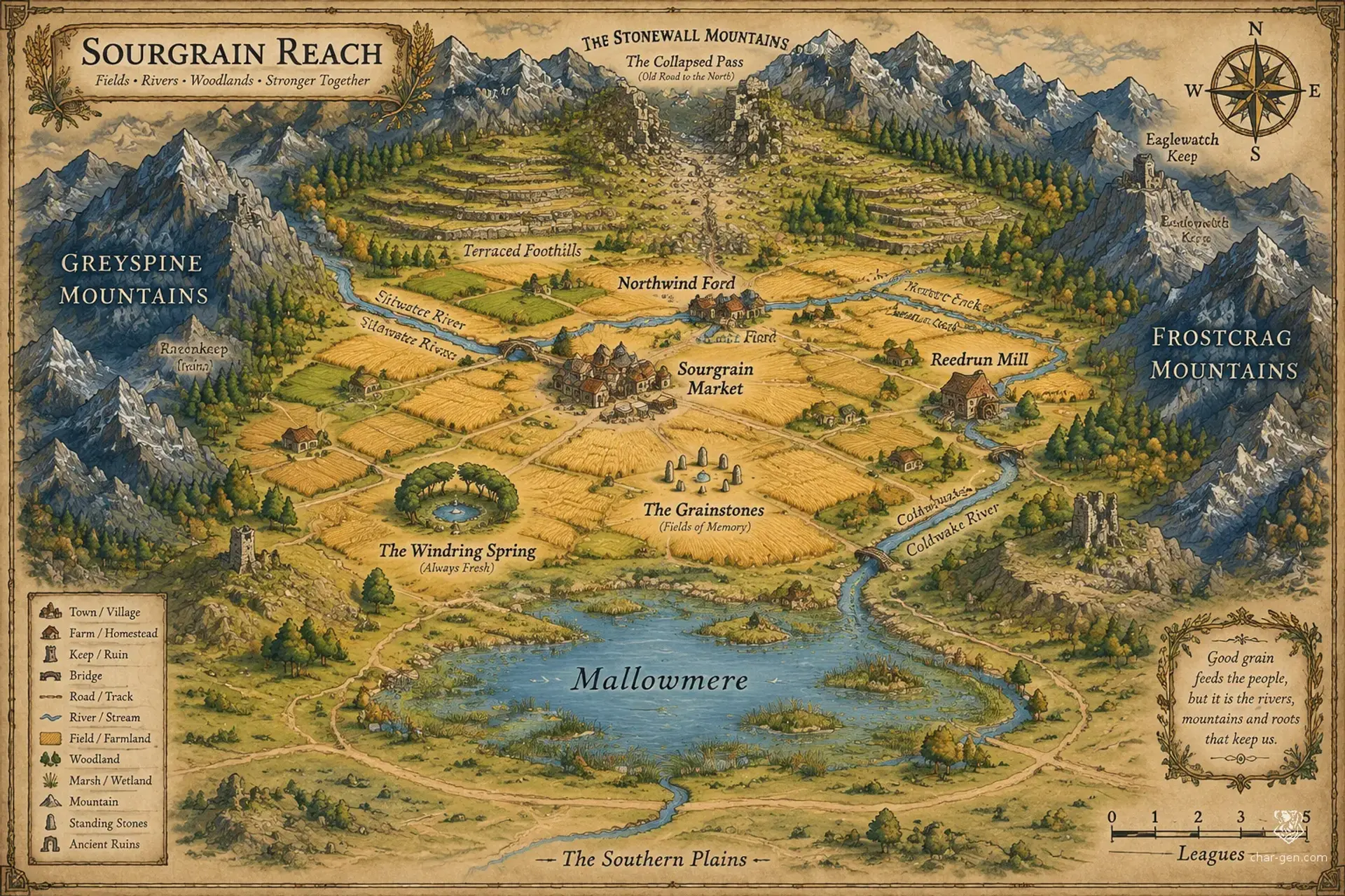
Sourgrain Reach is a broad frontier of working farms and open grassland, roughly a hundred miles across, held between mountains to the north, east, and west. Its communities follow rivers and field roads, with the southern plains offering the easiest route for newcomers. Magic is common enough to aid irrigation, preserve harvests, and complicate old boundaries. Prosperity is possible here, but every settlement must negotiate with its neighbors, the weather, and the untamed country at its edges.
Cultures
The Plowland communities mark the year with shared sowing days, harvest feasts, and obligations to maintain common roads.
Mountain-edge families blend farming customs with herding, quarry work, and seasonal travel through the passes.
Recent settlers bring varied crafts and magical practices, often adapting them to local weather and communal needs.
Places
4 settlements
Large · Market townSourgrain MarketRegional grain exchangeA crowded grain town known for sharp bargaining, muddy streets, and a large public granary.
Medium · Road townNorthwind FordMountain gateway and caravan stopA river crossing at the foot of a northern pass, often busy with drovers and prospectors.
Small · Waystation settlementLanternweather YardMeeting place and trade fairA cluster of inns, sheds, and council buildings that fills with visitors during seasonal assemblies.
Small · Mill hamletReedrun MillFlour production and water managementA mill village built beside a reliable creek, with fields prone to sudden flooding.
How they spread
PatternMost settlements cluster along the Siltwater and the safest roads, with isolated homesteads spreading across the central plains. Larger markets appear where river crossings, mills, and mountain routes meet.
Common kinds
Farm villages
Market towns
Mill hamlets
Quarry camps
Roadside inns and waystations
Trade routes
The southern grain road links the plains to distant markets.
The pass road carries stone and ore from the northern foothills.
A river route connects Siltwater farms with downstream traders.
Dangers and hooks
4 threats
Most dangerous · HighGully FloodsNatural hazardSeasonal torrents threaten foothill farms, bridges, and anyone traveling in narrow valleys.
The Passfall RaidersModerateHumanoid raiders
Small bands appear on isolated roads, especially when snow blocks the northern pass.
The Rooted HerdModerateMonstrous wildlife
A few unusually aggressive beasts roam the western grasslands and trample fenced fields.
The FieldwokenLowWild magic manifestations
Strange figures are reported near standing stones and fallow fields after storms.
Hazards of the land
Flash floods race down foothill gullies after heavy rain.
Sinkholes open in fields above abandoned stone workings.
Late frosts can destroy young crops across entire valleys.
Wild magic sometimes makes familiar paths seem to shift after dusk.
Plot hooks
1
The Uphill DitchMystery and explorationA village's irrigation channel has begun flowing uphill at night, flooding fields and exposing an ancient paved surface.Starts: The water wardens at Sourgrain Market offer work after local farmers accuse one another of sabotage.Reward: A share of recovered valuables, local land rights, and a charm that guides water through dry ground.
2
Seed Before SunriseRescue and wildernessA missing caravan carried seed grain needed for the next planting, and fresh tracks lead toward a flooded ford.Starts: Merchants at Northwind Ford hire escorts before the trail disappears under rising water.Reward: Payment, reliable mounts, and a favor from the caravan's trading house.
3
The Speaking QuarryDungeon explorationA quarry crew broke into a sealed chamber where a cold wind carries voices that predict accidents.Starts: The Hammer and Cart Syndicate asks the party to inspect the chamber before workers return.Reward: A choice of mineral rights, crafted equipment, or an enchanted tool.
4
Stones in the Wrong FieldInvestigation and negotiationSomeone is altering boundary stones to push several farms into a disputed marsh and claim the fertile land beyond.Starts: A public hearing at Lanternweather Yard turns hostile when a witness vanishes.Reward: A regional council's support, a parcel of land, or a legal writ granting passage.
The land
Climate and ground
ClimateTemperate, with wet springs, warm summers, crisp autumns, and occasional hard winter storms rolling off the mountains.
TerrainBroad rolling plains lie between mountain ranges to the north, east, and west, broken by low ridges, river valleys, and scattered woods.
Biomes
Temperate grassland, River meadow, Mixed woodland, Foothill scrub, Seasonal marsh
Waters and borders
Waterways
The Siltwater River winds south through the central farms.
The Reedrun Creek drains the western foothills into the Siltwater.
The Coldwake River descends from northern snowfields.
Mallowmere is a shallow lake edged by seasonal marsh.
Borders
Northern mountain wall and its narrow passes
Eastern ridges and high valleys
Western mountains and broken foothills
Open southern grasslands
On the road
Spring floods can make lowland tracks impassable for days.
Mountain passes are usable in fair weather but may close under early snow.
Old field roads cross private land, so travelers should ask before camping or cutting crops.
Landmarks
A line of standing stones crosses several working fields.
The collapsed northern pass reveals masonry beneath the scree.
A ring of wind-bent trees surrounds a spring said to answer whispered questions.
Old irrigation channels run straight across ridges that should have stopped them.
Landforms
Wide, rolling grain plains
Terraced northern foothills
Low limestone ridges
Marshy lake margins
Resources
Fertile loam
Limestone and building stone
Copper ore
Freshwater and grazing land
Power
Rule
GovernmentA loose league of settlement councils, farm assemblies, and market delegates coordinates shared roads, water rights, and defense.
SeatSeasonal councils convene at Lanternweather Yard, a neutral meeting ground beside the main southern road.
StabilityGenerally steady, but disputes over water, land grants, and frontier security can turn neighboring communities against one another.
Laws
Harvest shares and milling fees must be recorded before grain is stored.
Anyone diverting a shared watercourse must restore its flow after use.
Carrying drawn weapons in a market requires a declared purpose.
Unlicensed spellwork that endangers crops, wells, or livestock is punishable by restitution.
Factions
The Plow and Sickle CompactFarmers' coalition
Influence: Strong in the central farming settlements and influential at seasonal councils.Secure fair grain prices and keep common wells, roads, and mills in working order.
The Hammer and Cart SyndicateTrade and quarry consortium
Influence: Growing around the eastern and western foothills.Win contracts to reopen old quarries and extend protected roads toward the mountain passes.
The Rainbell CircleHedge-mage fellowship
Influence: Respected across the region, though their authority is informal.Regulate risky spellwork while preserving useful local charms and weather rites.
Faiths
The Furrow Mother
Influence: Widespread among farming families, with rites often held at planting and harvest.Seasonal renewal, field fertility, and obligations between neighbors.
The Quiet Lantern
Influence: Common among merchants, teamsters, and households near the main routes.Roadside protection, safe crossings, and welcome for travelers.
The Deep Hearth
Influence: Strong among quarry workers and foothill communities.Mountain endurance, honest labor, and respect for the dead beneath the stone.
People and trade
Who lives here
How manyLight to moderate, concentrated along rivers, roads, and fertile strips beneath the mountain passes.
Main peoples
Human farming communities
Halfling tenant farmers and traders
Dwarven quarry workers and metalwrights
Other peoples
Orcish herders from the western foothills
Gnomish hedge-mages and surveyors
Languages
Common, Halfling, Dwarvish
Trade
WealthModest overall, with prosperous river markets and isolated hamlets that rely heavily on barter.
The region began as a scatter of farms founded by families seeking room beyond crowded southern lands. Repeated floods and dry years taught the settlers to maintain shared roads and irrigation works, though those agreements remain fragile. The recent collapse of a northern pass revealed traces of an older road beneath the mountain scree, drawing prospectors and raising questions about what once crossed the plains.
Key events
Three generations ago
First FurrowsFamilies from the southern grasslands established scattered farms beside the Siltwater and began clearing common roads.
Two generations ago
The Thirst YearsA succession of dry summers pushed settlements to create shared irrigation channels and appoint water wardens.
Recent decades
The PassfallA sudden collapse in the northern pass exposed old stonework and brought prospectors, mages, and competing claims into the region.
Secret 1 · GM only
The old road was built to carry more than traders, and its hidden waystations were deliberately buried after a forgotten magical disaster.Found by: The standing stones align with the buried road visible beneath the northern pass.If found: The road leads to a sealed waystation containing records that could overturn several settlement land claims.
Secret 2 · GM only
The spring preserves fragments of memory from the land itself, but repeated use wakes a presence below its waters.Found by: At the wind-bent spring, a reflection may show fields as they appeared generations ago.If found: The visions can reveal the source of local wild magic or expose a concealed act of land theft.
Media
0 images
No images yet.
Visual sheet
Turn Sourgrain Reach into a sheet
A high-res, share-ready sheet you can post or print.