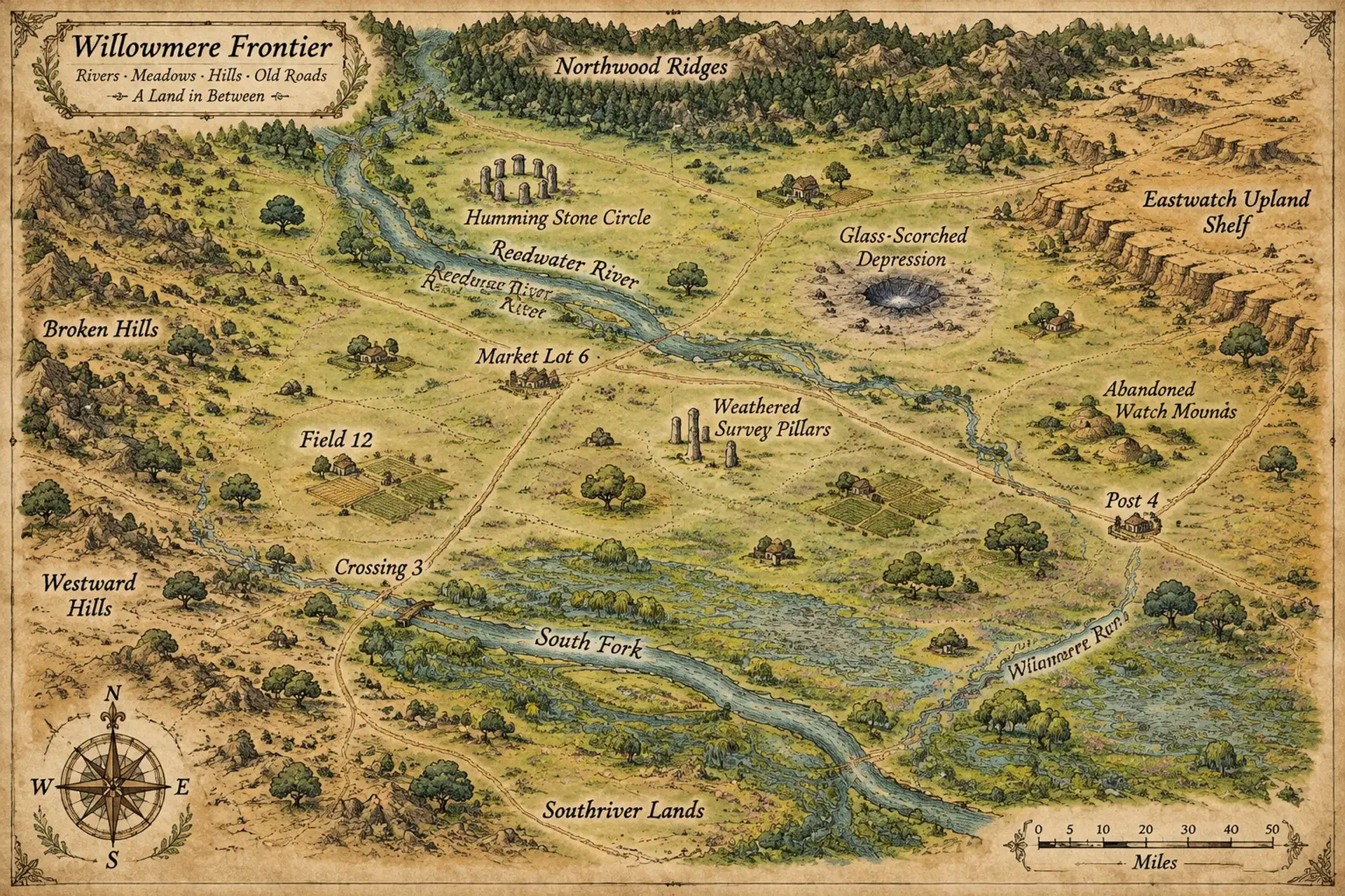
Where every mile is open country and every old boundary hides a story.
SMSurvey 14 March
Overview
Survey 14 March is a wide frontier of temperate grasslands, shallow rivers, and scattered settlements spread across roughly a hundred miles. Its open horizons make travel seem simple, yet storms, disputed land claims, and old magic complicate every journey. Farmers, herders, caravaners, and prospectors share the plains with creatures drawn to the region's lingering enchantments. Communities are far apart, so a single missing patrol or failed harvest can become everyone's concern.
Cultures
The Long Furrow tradition values shared labor, seasonal feasts, and careful inheritance of pasture rights.
The Roadward custom welcomes newcomers who contribute to communal defenses and keep their trade promises.
The Lantern school blends practical spellcraft with folk charms used to protect homes, crops, and livestock.
Places
4 settlements
Large village · Market townCrossing 3River crossing and caravan stopA busy ferry and stockade grew around an old survey crossing.
Small town · Market townMarket Lot 6Regional trade and assembly siteIts open square hosts weekly auctions and public meetings.
Village · Farmstead clusterField 12Grain-producing villageFarms and a shared granary surround a low defensive palisade.
Hamlet · WaystationPost 4Roadside refuge and patrol stationTravelers can find a stable, a well, and a lantern tower here.
How they spread
PatternSettlements cluster around reliable water, defensible crossings, and productive soil, with isolated farms and camps between them. The northern and eastern edges are more lightly settled than the river districts.
The South Fork wagon road links river settlements with the southern markets.
The Marker Track follows old survey pillars across the central plains.
The Ridge Road skirts rough ground and connects prospecting camps to farm towns.
Dangers and hooks
3 threats
Most dangerous · HighSurvey WraithsUndead spiritsThey appear near old boundary pillars and pursue anyone who moves the stones.
The Tallgrass StalkersModeratePredatory beasts
They shadow isolated herds and strike when storms obscure the horizon.
The Grassfire FrontVariableEnvironmental and magical hazard
It returns during dry, windy seasons and sometimes moves with unnatural purpose.
Hazards of the land
Fast-moving spring floods
Grass fires driven by high winds
Sinkholes concealed beneath tall grass
Plot hooks
1
Tracks Between the MarkersMissing caravanA wagon train has vanished near a line of survey pillars, and fresh tracks lead into a field that appears empty from the road.Starts: The caravan's families wait at Crossing 3 for someone to search the prairie.Reward: A share of recovered cargo, local goodwill, and a serviceable wagon.
2
The Well on the LineDisputeTwo settlements claim the same well after an old boundary stone shifts overnight.Starts: A mediator at Market Lot 6 asks the party to inspect the marker before armed claimants arrive.Reward: A land deed, a modest fee, or the right to draw water during the dry season.
3
Fire That ChoosesSupernatural mysteryA grass fire moves against the wind and circles a ruined watch mound instead of burning toward nearby farms.Starts: A herder brings the strange report to a local shrine-keeper.Reward: A charm against fire, rare herbs, and the gratitude of threatened families.
4
Lines Beneath the SoilExplorationA newly uncovered stone chamber contains maps whose boundaries predate every known survey.Starts: A prospector offers the party a share in whatever can be safely recovered.Reward: A magic map, old coin, or a claim to a hidden resource.
The land
Climate and ground
ClimateTemperate, with warm growing seasons, cold winds in winter, and occasional violent spring storms.
TerrainBroad open plains interrupted by shallow valleys, low ridges, and gently rolling farmland.
Biomes
Tallgrass prairie, Flowering meadow, Willow-lined wetland, Scattered oak savanna
Waters and borders
Waterways
The Reedwater River, The South Fork, Willowmere Run
Borders
Low wooded ridges to the north
A dry upland shelf to the east
The settled riverlands to the south
A broken chain of hills to the west
On the road
Wagon travel is easy in dry weather but becomes slow and treacherous after heavy rain.
Few landmarks rise above the grass, so travelers rely on waterways, old survey stones, and local guides.
Common magic helps with navigation and farm work, but sudden storms can still strand caravans.
Landmarks
A circle of standing stones that rings softly before storms
A long depression where no grass grows after the Glass Grass event
A line of weathered survey pillars extending across the prairie
A chain of abandoned watch mounds visible from great distances
Landforms
Broad grass-covered plains
Shallow river valleys
Low wind-cut ridges
Seasonal marsh basins
Resources
Fertile loam
Hardwood from scattered groves
Iron-bearing stones
Medicinal prairie herbs
Power
Rule
GovernmentA loose frontier compact of settlement councils, landholders, and chartered trade groups.
SeatThe regional assembly meets in a rotating market settlement, chosen each season by participating communities.
StabilityUneven but functional, as shared threats encourage cooperation while land and toll disputes remain constant.
Laws
Marked wells and river access must remain open to travelers during emergencies.
A finder must report buried survey markers before claiming nearby land.
Armed companies may not demand tolls without a publicly posted charter.
Factions
Lot C AssemblySettler council
Influence: Strongest in settled districts, but dependent on local cooperation.They seek common rules for grazing, water access, and protection of exposed farms.
Route 11 CompanyCaravan consortium
Influence: High along the main caravan tracks and uneven elsewhere.They want safer roads and exclusive control over several lucrative toll crossings.
The Hearth and Star CovenantMystic order
Influence: Quiet but respected in communities near the old markers.They guard ancient standing stones and restrict reckless use of powerful magic nearby.
Faiths
The Hearthward Way
Influence: Common in settled villages and among farming families.Honors hearths, harvests, and the bonds between neighbors.
The North Lantern
Influence: Widespread along roads and especially strong among caravaners.Treats stars, weather, and omens as signs that guide travelers and spellcasters.
The Water and Grass Vow
Influence: Locally influential near waterways and open pasture.Reveres the spirits of wells, rivers, and grazing lands through offerings and seasonal rites.
People and trade
Who lives here
How manySparse across the open grasslands, with denser clusters around wells, market towns, and defended crossings.
WealthModest overall, with seasonal prosperity among successful traders and landholders.
Work
Grain and pulse cultivation, Cattle and horse raising, Milling and wagon repair
Exports
Wheat, Horses, Wool, Milled flour
Imports
Iron tools, Salt, Fine cloth
Markets
Crossing 3, Market Lot 6
History and secrets
The plains were long used as seasonal pasture before surveyors and settlers began dividing them into farms and grazing claims. Early communities built scattered forts and market towns, relying on shared wells and river crossings. Floods, disputes over land, and intermittent surges of wild magic have shaped the region's uneasy compact. Old markers still matter, and some conceal boundaries far older than the settlers' maps.
Key events
Early settlement
The First LinesSurveyors laid out a grid of claim markers, many of which still shape property disputes and local boundaries.
Three generations ago
The River's TurnA flood shifted the Reedwater River and isolated several communities, prompting the first shared road and bridge agreements.
Recent decades
The Glass GrassA wave of wild magic scorched an empty stretch of prairie and left standing stones humming beneath the soil.
Secret 1 · GM only
The old markers were placed to contain, not divide, an immense source of wild magic.Found by: The standing stones answer certain spells with a tone that matches notes found in an old surveyor's journal.If found: The stones are part of a buried network that can redirect magical surges across the plains.
Secret 2 · GM only
The Glass Grass was caused by a brief opening to another plane, and the opening is slowly returning.Found by: At dawn, the grassless depression reflects a constellation that is not visible in the region's night sky.If found: A hidden route through the depression leads to a sealed chamber and may attract planar attention.
Media
0 images
No images yet.
Visual sheet
Turn Survey 14 March into a sheet
A high-res, share-ready sheet you can post or print.