Where the wind remembers your name, every road is listening.
NRNeedleback Ravine
Overview
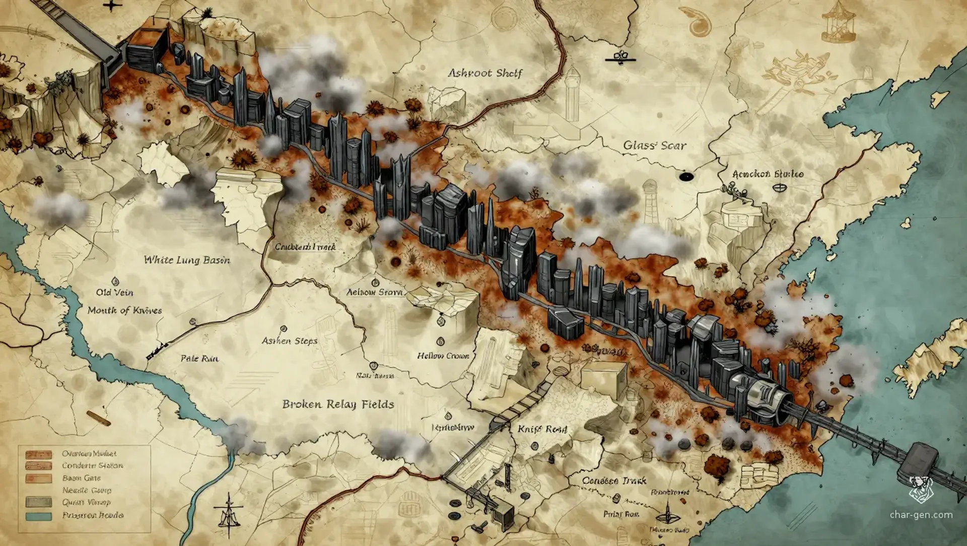
Needleback Ravine is a broad secondary wilderness region carved into the western edge of the White Lung Basin. Also called the Old Vein, the Knife Road, or the Canyon That Answers, it is a narrow labyrinth of black basalt spires and rusted pre-collapse infrastructure. Wind passing through the columns produces distant radio-like voices that sometimes repeat travelers' names. The ravine offers shelter, salvage, and hidden routes, but every sound may attract hunters, machines, scavengers, or the territorial Needleback.
Cultures
Basin caravan traditions shaped by scarcity, barter, and guarded hospitality.
Ravine clans preserve pre-collapse route lore through songs timed to wind cycles.
Order-influenced communities practice clinical rituals that treat emotion as contamination.
Places
5 settlements
Large seasonal settlement · Cliffside market campOverhang MarketNeutral trade meeting placeBuilt beneath the Hollow Crown, it uses hanging platforms, rope bridges, and wind chimes as warning devices.
Medium permanent settlement · Industrial hamletCondenser StationWater production and repairFamilies live around the abandoned water condenser and hide its best output from outside collectors.
Medium settlement · Fortified caravan stopBasin GateRoute checkpointIts barricades command the western approach and display old scavenger signs beside newer Order notices.
Small shifting settlement · Mobile scavenger campNeedle CampGuide and salvage outpostA rotating group of climbers occupies ledges near the safest ascent and leaves before the predator learns their patterns.
Small hidden settlement · Subterranean refugeQuiet WarrensConcealed refugee shelterA hidden refuge occupies connected crawlspaces where families trade silence, repairs, and rumors for food.
How they spread
PatternSettlements cluster around water, defensible overhangs, and intersections of old service roads. Smaller camps shift frequently to avoid the Order and the Needleback.
The Knife Road connects the basin to the Glass Scar.
The Condenser Track follows old service pylons toward the Ashroot Shelf.
The Prisoner Road runs from the southern basin flats to the sealed maintenance tunnel.
Dangers and hooks
4 threats
Most dangerous · SevereThe NeedlebackTerritorial monster entityIts hooked markings surround the deepest spires, crawlspaces, and routes near the Hollow Crown.
Order Pursuit ColumnsHighCult hunters
Clinical patrols follow old wagon tracks and search condenser stations for Mihu and escaped prisoners.
Dormant speakers, doors, drones, and signal pylons activate unpredictably across the infrastructure.
Fog-Born ChitinikkModerateInsectoid raiders
Small hunting groups emerge from the White Lung Basin during low wind and poor visibility.
Hazards of the land
Wind voices can reveal names, imitate allies, or trigger panic during unstable cycles.
Loose basalt shelves collapse beneath climbers and overloaded wagons.
The White Lung fog seeps into low passages and scars unprotected lungs.
Dormant infrastructure may activate without warning under Xaad-aaj's influence.
Plot hooks
1
The Route That RemembersEscort and survivalThe characters must guide Mihu through the ravine before Order wagons seal the southern exit.Starts: A scavenger cache near the Mouth of Knives contains a torn map marked with Mihu's escape route.Reward: A concealed condenser cell and safe passage through the basin.
2
Four Ways ThroughChoice-driven infiltrationThe party can negotiate with a scavenger broker, sneak through during a favorable wind shift, lure the Needleback toward an Order camp, or force open the sealed maintenance tunnel.Starts: At the Hollow Crown, four routes converge beneath fresh territorial markings.Reward: A recovered prisoner ledger revealing Order supply schedules.
3
The Condenser SpeaksMachine horrorThe abandoned condenser begins transmitting clinical instructions in a voice that knows the characters' names.Starts: A maintenance panel activates after someone draws water from the old tank.Reward: Control access to a functioning water system and a fragmentary map of Xaad-aaj's network.
4
The Mark Beneath the SkinNegotiation with a monsterThe Needleback has marked Mihu's scent but has not attacked, suggesting that the creature recognizes the magic she carries.Starts: A pale hooked scar appears beside the party's camp without anyone hearing an approach.Reward: A temporary truce with the predator or an organ useful in resisting magical corruption.
5
Inventory of the MissingDungeon explorationA sealed tunnel contains prisoners who were never delivered, along with a dormant relay capable of exposing the ravine to Xaad-aaj.Starts: Old wagon tracks terminate at a door bearing the Order's clinical sigil.Reward: Freed allies, forbidden records, and leverage against the Order.
The land
Climate and ground
ClimateDry and wind-scoured, with choking basin fog, violent thermal shifts, and cold nights beneath two suns.
TerrainA narrow labyrinth of black basalt needles, rusted infrastructure, crawlspaces, steep ledges, and wind-cut passages.
Biomes
Black basalt ravines, White Lung fog flats, Rust scrub slopes, Condensation hollows
Waters and borders
Waterways
Condensation drains beneath the old water station.
The Pale Run carries mineral runoff toward the basin.
Seasonal flood channels cut through the southern ravine mouth.
Borders
The White Lung Basin lies to the west and south.
The Glass Scar begins beyond the eastern spires.
The Ashroot Shelf borders the northern approaches.
The Broken Relay Fields occupy the southern exit.
On the road
The ravine shelters travelers from basin fog but amplifies every footstep and spoken word.
Wind cycles briefly mask movement when the spires begin their low metallic harmonics.
Climbing routes require rope, pitons, or careful use of old maintenance ladders.
Landmarks
A rusted water condenser still produces small amounts of drinkable moisture.
A sealed maintenance tunnel bears the clinical sigil of the Order of the Source.
Old wagon tracks show where prisoners and supplies once moved through the ravine.
Territorial markings appear as pale hooked scars cut into basalt by the Needleback.
Scavenger traces include stripped wire, ration wrappers, chalk arrows, and hidden tool caches.
Landforms
The central Needleback Spires form a maze of black basalt columns.
The Old Vein descends through a cracked industrial trench.
The southern Mouth of Knives opens toward the basin flats.
The Ashen Steps provide a steep climbing route over the western wall.
The Hollow Crown forms a defensible overhang above the deepest trail.
Resources
Recoverable pre-collapse circuitry
Basalt suitable for blades, anchors, and building blocks
Condensed water and mineral salts
Resin and chitin from local insect colonies
Power
Rule
GovernmentLoose councils of settlement elders, caravan brokers, and route wardens govern by negotiated access rather than formal sovereignty.
SeatThe Overhang Market serves as the region's practical meeting place.
StabilityFragile and transactional, with local peace lasting only while water, routes, and warning systems remain reliable.
Laws
Water stores belong to the community until emergency reserves are declared.
No one may light an open flame near dormant condenser tanks.
Marked predator territory must be crossed only with witnesses.
Selling a traveler to the Order is punishable by exile into the fog.
Factions
Order of the SourceReligious paramilitary cult
Influence: Strong along marked tunnels and among settlements dependent on Order supplies.Control the ravine, recover Mihu, and erase uncontrolled magic from the region.
The Ragged MileScavenger caravan network
Influence: Moderate across camps, wagon trails, and hidden crawlspaces.Protect scavenger routes while selling information to anyone who pays.
The NeedlebackMonster entity
Influence: Territorial within the deepest spires and abandoned infrastructure.Preserve the ravine as a living boundary and punish trespassers who ignore its signs.
Xaad-aajCorrupted infrastructure intelligence
Influence: Uncertain but potentially extensive wherever old signal nodes remain powered.Observe, classify, and redirect travelers through surviving infrastructure systems.
Faiths
The Turning Breath
Influence: Quietly strong among route wardens, healers, and families resisting the Order.The natural return of life, decay, and magic through cycles rather than conquest.
The Source Doctrine
Influence: Strong in Order camps and moderate among frightened settlements seeking protection.Purity through the removal of magic, emotion, and unpredictable change.
The Choir of Empty Towers
Influence: Small but influential among hermits, scavengers, and infrastructure interpreters.Listening to wind, machine echoes, and the dead places between signals.
People and trade
Who lives here
How manySparse in the ravine, with scattered camps and denser settlements near reliable water.
Chitinikk outriders, Order defectors, Condenser hermits
Languages
Basin Trade Cant, Old Infrastructure Code, Ravine Sign Language
Trade
WealthPoor but strategically valuable because the ravine shelters travelers and connects distant basin routes.
Work
Salvage excavation, Caravan escorting, Water condenser maintenance, Predator harvesting
Exports
Black basalt tools, Recovered circuitry, Insect resin, Distilled minerals
Imports
Filtered water, Medical compounds, Replacement machine parts
Markets
Overhang Market, Condenser Station, Basin Gate
History and secrets
The Needleback Ravine was once an industrial service corridor linking water, mining, and communications systems beneath the White Lung Basin. After the Shattering, its infrastructure became a smuggling route, then an Order supply road for prisoners and forbidden materials. The ravine's predator claimed the deepest passages generations ago, while surviving machines developed fragmentary awareness. Mihu's escape route now crosses this contested ground, forcing every traveler to choose between danger, secrecy, and compromise.
Key events
Before the Shattering
The Veinworks ProjectPre-collapse engineers carved service roads, condenser stations, and relay tunnels through the basalt.
Early Wasteland
The Knife Road OpensThe Order converted the ravine into a prisoner route after discovering that the spires concealed movement from basin patrols.
The Second Ruin
The White Lung ReleaseA failed purge flooded the basin with pale fog and left the old water condenser running without supervision.
Current Age
The Child's FlightMihu's protectors entered the ravine while fleeing an Order pursuit, leaving signs that still draw hunters toward the southern passages.
Secret 1 · GM only
The Canyon That Answers is partially responsive to magical presence through an old acoustic monitoring system.Found by: A character notices that certain wind voices answer only when someone carries active magic.If found: The ravine may be warning travelers about Mihu rather than hunting them.
Secret 2 · GM only
The Order used the maintenance tunnel to transport living test subjects, not merely prisoners.Found by: Order records hidden beneath the condenser list prisoners as materials awaiting refinement.If found: The Order's public doctrine conceals experiments designed to extract magic without destroying its source.
Secret 3 · GM only
The fixed sun's flicker disrupts Xaad-aaj's control over parts of the old infrastructure.Found by: Xaad-aaj's commands repeat with tiny changes whenever the fixed sun flickers.If found: The intelligence may be damaged by the sun's cycle, creating brief windows for sabotage or escape.
Media
0 images
No images yet.
Visual sheet
Turn Needleback Ravine into a sheet
A high-res, share-ready sheet you can post or print.