Where the levees hold, the barges run, and old water remembers.
SRSaltpan Reach
Overview
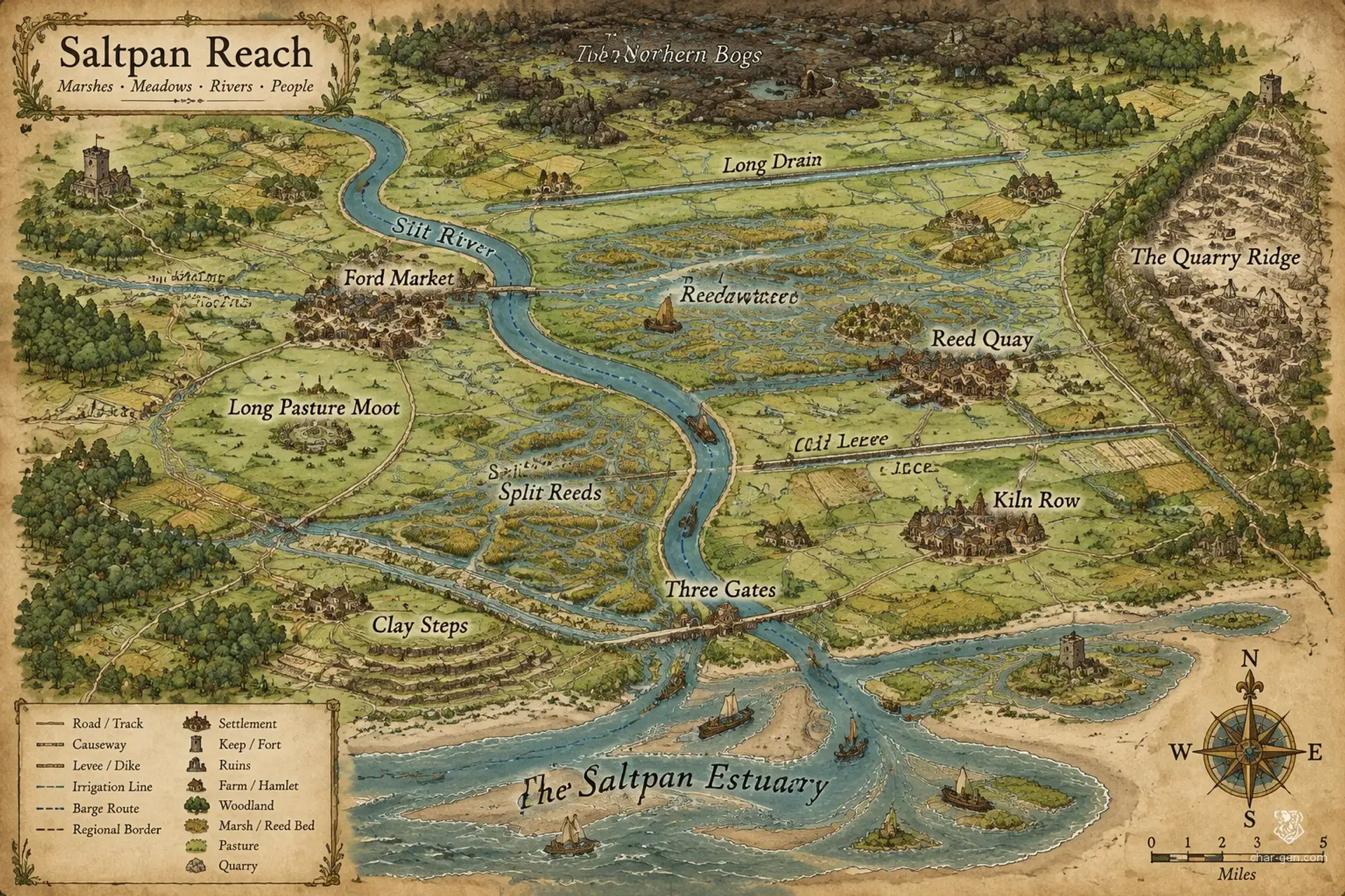
Saltpan Reach is a broad, lowland region where marsh channels, raised farm roads, and grazing ridges shape daily life. Its settlements are numerous but dispersed, gathering around reliable crossings, levees, and market landings rather than a single dominant city. Barges carry grain and brick toward the southern estuary, while local councils bargain over water and tolls. The region suits journeys of negotiation and exploration, where flood, faction, and wilderness can complicate even a short trip.
Cultures
The Reedbank communities prize shared irrigation, seasonal festivals, and negotiated access to fishing grounds.
The upland herders keep clan histories through songs and welcome travelers who respect grazing boundaries.
The canal towns blend river customs with guild traditions brought by generations of merchants.
Places
4 settlements
Large · Market townFord MarketRegional meeting place and inland trade center.Its shallow crossing, weekly markets, and council hall draw visitors from across the basin.
Medium · Barge townReed QuayMarsh trade hub and boat-repair stop.Barge crews, fish sellers, and rope makers crowd its raised landing.
Small · Industrial villageKiln RowManufacturing center on the Clay Track.Its smoke-blackened yards produce bricks and tiles from nearby clay banks.
Variable · Seasonal campLong Pasture MootHerders' assembly and livestock market.A seasonal gathering ground becomes a busy camp during herd exchanges and council meetings.
How they spread
PatternSettlements follow waterways, causeways, and patches of high ground, with the densest clusters near crossings and market landings. Farms and fishing hamlets remain widely scattered across the basin.
Common kinds
Levee villages with clustered farms and raised communal stores.
Barge towns built around landings and repair yards.
Quarry hamlets near the eastern ridge.
Seasonal herder camps on dry grassland.
Trade routes
The Silt River barge route links inland grain towns to the southern estuary.
The Old Levee road carries carts between the central markets and western pasture.
The Clay Track connects eastern quarry hamlets to the brick kilns.
Dangers and hooks
3 threats
Most dangerous · HighThe Drowned ChoirUndeadUnquiet dead gather around flooded ruins during fog season.
Fen StalkersModeratePredatory monsters
They haunt isolated causeways at dusk and retreat into deep channels when challenged.
Levee CuttersVariableBandits
Small armed bands sabotage barriers and extort isolated villages.
Hazards of the land
Seasonal floods can erase roads and isolate entire settlements.
Sucking mud and hidden channels endanger travelers who leave marked paths.
Swarming marsh insects carry fever during the warmest months.
Plot hooks
1
The Broken RotationInvestigationA sluice gate has been sabotaged, and the resulting flood threatens farms that supply several towns.Starts: The Sluice Keepers hire the party at Three Gates.Reward: A purse of silver, a waterway charter, and a favor from the canal guild.
2
Cargo in the ReedsExplorationA barge carrying grain vanished after taking a channel that locals insist was dry.Starts: A worried factor approaches the party at Reed Quay.Reward: Recovered trade goods and a share of the barge's salvage.
3
The Sinking HerdMonster huntSomething beneath the peat is drawing livestock into the bog and leaving tracks that end in open water.Starts: A herder asks for help at Long Pasture Moot.Reward: Coin, mounts, and safe passage through the western grazing lands.
4
Ink Against WaterIntrigueA forged council record assigns the same canal water to three rival communities.Starts: A clerk at Ford Market offers the party access to the council archive.Reward: A legal bounty and political support from one settlement of the party's choice.
The land
Climate and ground
ClimateTemperate and damp, with mild summers, frequent mist, and cold wet winters.
TerrainA broad, low basin of marsh, pasture, and braided waterways broken by scattered gravel ridges.
Biomes
Temperate marshland
Reed-fringed freshwater wetlands
Open grassland and pasture
Mixed riverside woodland
Waters and borders
Waterways
The Silt River winds through the central basin.
The Long Drain links inland farms to the southern estuary.
The Reedwater channels split into shifting marsh passages.
The White Ford stream descends from the eastern ridge.
Borders
The eastern boundary rises into a low, quarry-cut ridge.
The west fades into wind-scoured grazing plains.
Northern peat bogs separate the region from forest country.
The southern edge follows a broad estuary.
On the road
Raised causeways are dependable in summer but may vanish beneath winter floods.
Local guides are essential where reed channels shift after storms.
Barges travel faster than carts when the water gates are open.
Landmarks
The Split Reeds form a maze of waterways navigable only by shallow boats.
The Old Levee is a raised earthwork that doubles as a busy road.
The Clay Steps are exposed banks riddled with abandoned brick pits.
The Three Gates regulate much of the basin's irrigation and floodwater.
Landforms
A wide central flood basin crisscrossed by old levees.
Low gravel ridges that support dry roads and small villages.
Peat bogs with unstable islands of grass and brush.
A southern estuary fringed by tidal flats.
Resources
Rich alluvial soil supports abundant grain and bean harvests.
Reeds and rushes supply thatch, mats, and basket fiber.
Clay deposits feed brick kilns and tile workshops.
Freshwater fisheries provide food and export goods.
Power
Rule
GovernmentA loose league of town councils, canal guilds, and village moot assemblies governs through seasonal delegates.
SeatThe regional council convenes at Ford Market, but authority is distributed among town and waterway councils.
StabilityGenerally stable, though disputes over water access, tolls, and flood repairs can quickly turn violent.
Laws
Water gates must be shared by a posted rotation during dry months.
No bridge or canal toll may be collected without council record.
Cutting marked flood barriers is treated as a grave public crime.
Factions
The Sluice KeepersWaterworks guild
Influence: Strong among farmers and mill operators.They seek reliable water shares and protection for the villages that maintain the canals.
The Grain FactorsMerchant compact
Influence: Considerable in the larger market towns.They aim to keep tolls predictable and control the busiest barge landings.
The Long Pasture MootHerders' council
Influence: Strong in the western grazing country.They defend common grazing and oppose new fences across the upland routes.
Faiths
The Hearth and Furrow
Influence: Widely practiced in farm villages and market neighborhoods.Its worshippers honor hearths, harvest stores, and the cycle of planting and flood.
The River Vow
Influence: Strong among boat crews, fishers, and canal workers.Its rites ask river spirits for safe passage and fair water levels.
The Cairn Keepers
Influence: Most visible in upland hamlets and herder camps.Its adherents honor ancestors through cairns, memory songs, and communal feasts.
People and trade
Who lives here
How manyModerate overall, with dense clusters around waterways and widely spaced farms, hamlets, and seasonal camps.
Main peoples
Humans form the largest population in the canal towns and farming settlements.
Halfling families are numerous among the reedbank fishers and growers.
Dwarven communities work the eastern quarries and maintain many old roads.
Other peoples
Elf families keep small woodland enclaves near the northern marsh edge.
Dragonborn caravanners visit the trade roads throughout the year.
Languages
Common is used in markets and regional councils.
Reedcant is spoken along the marsh channels.
Highspeech is common among upland herders and quarry workers.
Trade
WealthModest and uneven, with prosperous river traders alongside poor seasonal laborers.
Work
Grain farming and water-meadow cultivation.
Fishing, eel trapping, and reed harvesting.
Canal transport and barge repair.
Clay extraction and brickmaking.
Exports
Grain and dried beans.
Reed mats, baskets, and thatch.
Eel leather and smoked fish.
Fired bricks and clay roof tiles.
Imports
Iron tools and nails arrive from eastern mines.
Salted fish and lamp oil come from the coast.
Fine cloth is carried in by long-distance caravans.
Markets
Ford Market, Kiln Row, Reed Quay
History and secrets
The basin's scattered communities grew around fishing grounds, pasture, and defensible crossings. Repeated floods taught them to build levees together, while dry years exposed the danger of leaving water control to any single town. Trade along the Silt River brought prosperity and outside customs, but also toll disputes and raids. The present league grew from practical agreements rather than conquest, and its unity remains strongest when floodwaters or hungry outsiders threaten everyone.
Key events
Founding years
The First Levee CompactFlooded farms prompted villages to organize shared levees and fixed water rotations.
The lean decades
The Gate DisputesA succession of dry summers led rival towns to contest control of the main sluices.
Recent generations
The Open Channel AccordLocal councils joined their toll records and patrols to reopen the southern barge road.
Secret 1 · GM only
The first levee builders concealed a second channel beneath the basin to protect their settlements during catastrophic floods.Found by: A set of old stone markers appears only when water levels fall below the lowest sluice notch.If found: The markers reveal a buried channel that could redirect floods and shift power among the towns.
Secret 2 · GM only
A respected merchant compact has secretly moved stolen relics through its ordinary grain barges.Found by: Compare the missing pages in the toll ledgers with unusual shipments of empty clay jars.If found: Exposing the smuggling route could destabilize the Grain Factors and draw dangerous attention to the party.
Media
0 images
No images yet.
Visual sheet
Turn Saltpan Reach into a sheet
A high-res, share-ready sheet you can post or print.